Discovering & Exploring Caves
In the last months, enthusiastic cave explorers have investigated and surveyed three caves near the village of Hail Al Hareem, one of which is a significant discovery for Oman. This article documents the preliminary surveying results and history of exploring these caves.
Caves provide important windows to the geological, hydrological, archaeological& climatic history of the earth. They have been for long considered as the archives of the past. The carbonate units of the Al Hajar Mountains and the Dhofar Mountains offer large numbers of caves to explore and study. Many of these have been discovered and surveyed, but many are still to be found. For adventurers, the exploration of caves is a challenge and life-time experience that requires dedication and consuming efforts. Whether you are a professional geologist, a pioneering explorer or a weekend adventurer, Oman offers a world-class set of spectacular caves, many of which are unexplored. Since the 1980’s large caves such as the Majlis al Jinn (Khoshilat Maqandeli), the Selmeh System, Al Hoota Cave (Kahf Al Hoti) and the sinkholes of Dhofar have been discovered and documented. Today we can add another significant cave and two smaller ones to the list of wonders in Oman.
Who should claim to have discovered a cave is an interesting topic. Caves have been around for millions of years, humans have been present for more than 100 000 years, so in the year 2017AD is it right to be the one claiming to have discovered a cave? Pinpointing when a cave was first explored can be a simpler task. if a cave has been entered there are normally signs such as stone steps, wooden pegs, artefacts, remains and in modern times metal climbing aids such as pitons or bolts.
All three caves recently explored, were certainly known to and have been named by local inhabitants. Villagers from Hail Al Hareem say the biggest cave, Al Khishil Cave was visited by Westerners in a helicopter many years ago. This report ties in with the 1980’s explorations by Don Davison & Cheryl Jones in conjunction with the Public Authority for Water Resources. Cheryl has confirmed they would have likely been the Western visitors but they did not enter the cave. In 2011, Tim Harrison, a hiker and photographer took a photograph of the entrance of Al Khishil Cave.
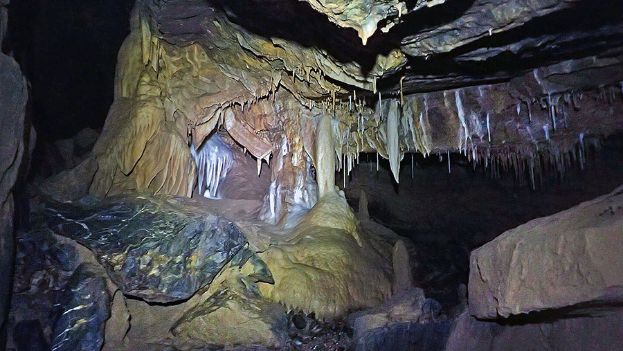
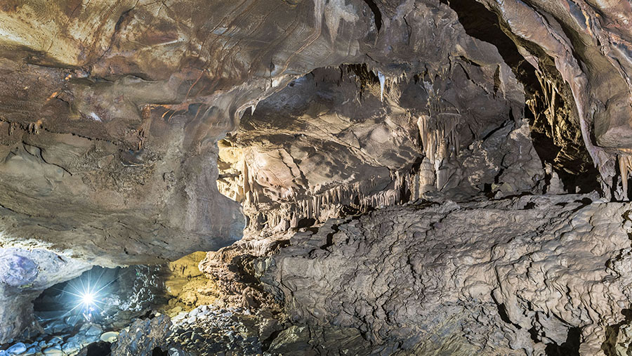
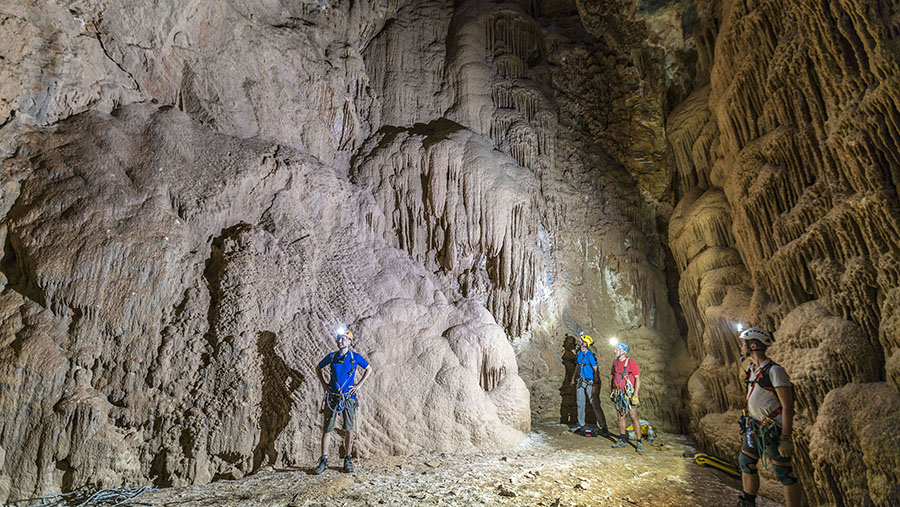
Al Khishil Cave
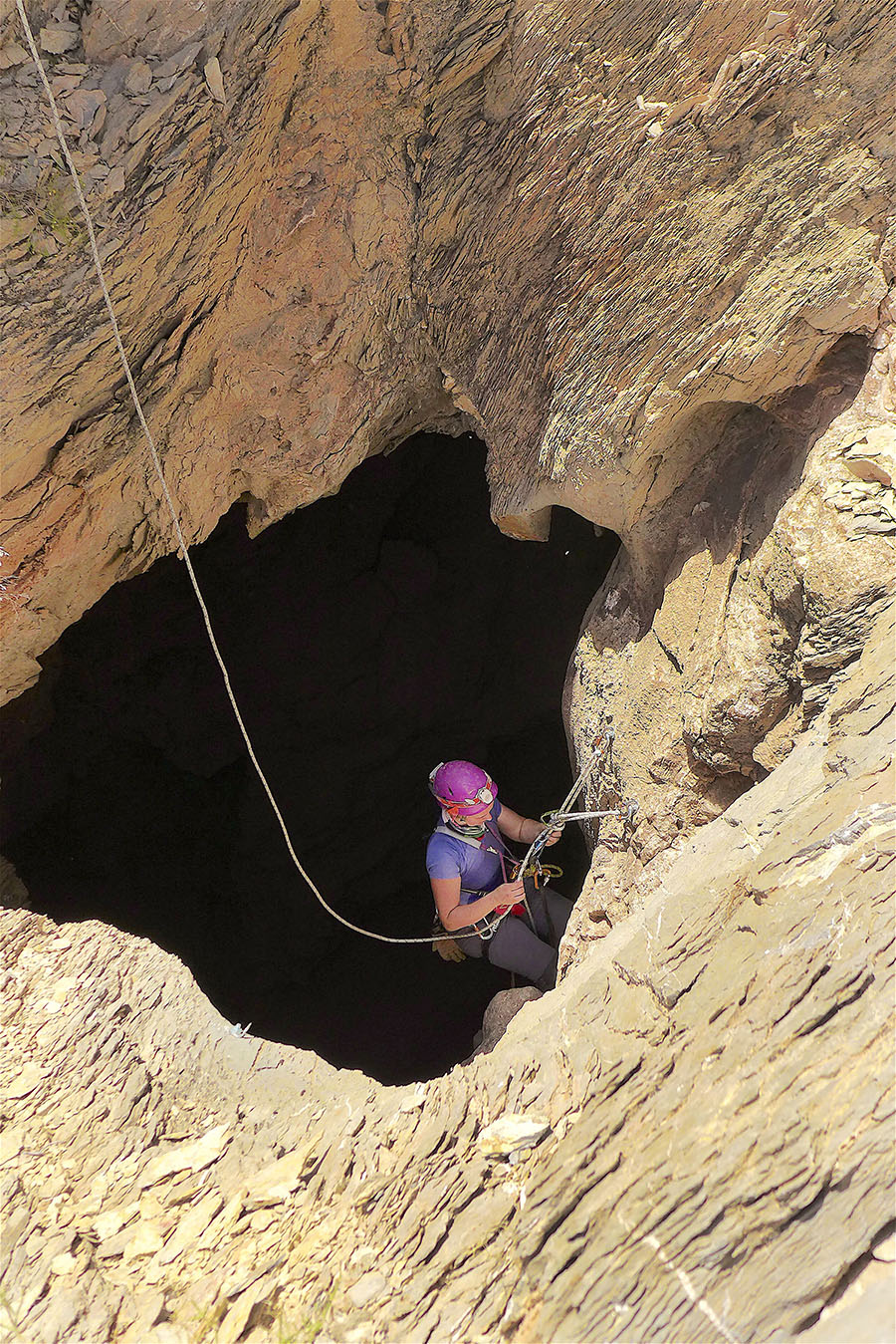
By chance, Simon Cahill, a British caver, came across a photograph Timhad posted on Panoramio of a different cave. Simon contacted Tim and Tim replied saying the cave was not deep but referring to the photo taken in 2011 of Al Khishil Cave Tim said he had another image that may be more interesting. Tim had not entered the Al Khishil Cave as it required climbing equipment and technical expertise but thought it was deep. Tim sent Simon the location and in December 2015 after caving on the Selmeh Plateau Simon and Blair Hoover a caver from the USA, stopped off to have a look. Simon and Blair rigged ropes from natural anchors and descended to a depth of 40m. The cave obviously went down a long way but without proper bolting equipment, Simon and Blair returned to the surface to plan further exploration.
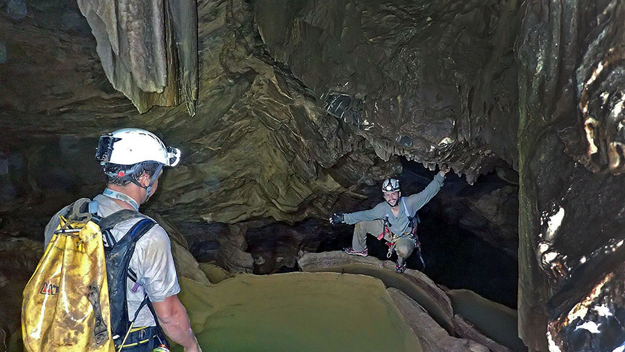
In January 2016 Canadian caver Christopher Pike joined Simon and Blair to explore the cave further. The initial pit with a drop of around 130m was bolted with several re-belays and deviations. Pike, a strong climber and caver took the lead on bolting. The walls of the pit had been polished by water to a fine smooth finish. It became clear nobody had been down there before; it was not possible to descend to the bottom without placing mechanical anchors. Beyond the main pit, the cave plunged again and quickly became varied and technically challenging with difficult climbs, traverses and a maze of tunnels to navigate. The cave opens into a decorated chamber Blair named The Art Gallery. The tunnel leading out from The Art Gallery twists and turns finally arriving at a wide low passage. Next comes a crawl/squeeze through water with an air gap no more than 30cm high. Pike hummed the theme tune to the film Mission Impossible; the crawl section was aptly named “Mission Impossible”. The cave narrows but the roof rises allowing a crawl on your knees rather than the previous squeeze on your stomach. Another tunnel with difficult climbs continues but the team had already explored several hundred meters of cave, with Blair taking survey notes along the way. At 6:35pm it was time to turn back. The cave was proving to be interesting, challenging and potentially dangerous. The nature of the cave constantly changes from tight low passages to open chambers. Mission Impossible is an early and dangerous sump; just a small amount of flood water can close off the way through or rather the way back! Later explorations have been stopped at this point as the cave has been flooded to the roof.
Survey and Mapping
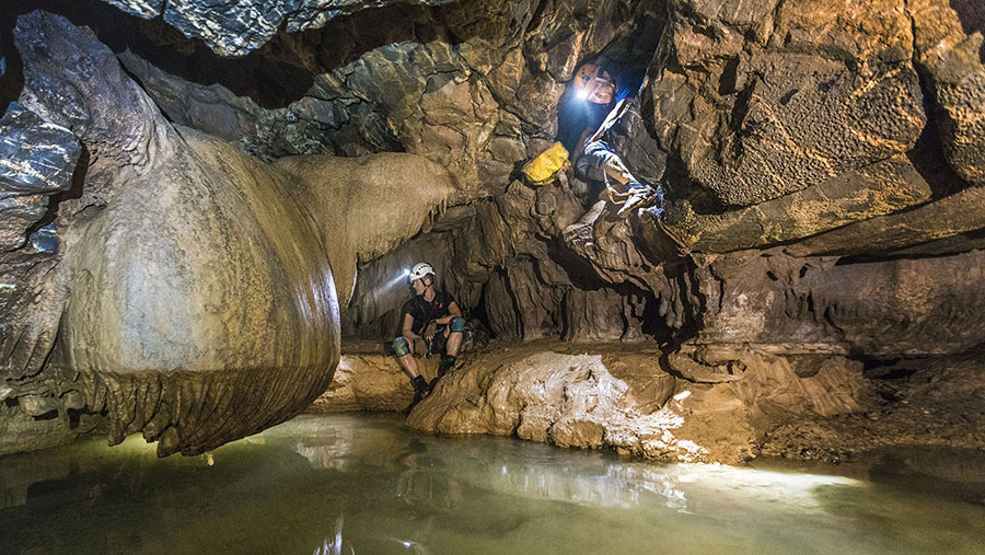
There have been several expeditions to the cave since 2015 to push exploration further and make surveys. The cave continues to be challenging. There is a lot of technical climbing with and without ropes. The cave is humid for the most part but can be cold after swimming through the numerous lakes and pools. Pike summed the cave up by saying; “the cave is the most technical in Oman by far and took a lot of rigging and sorting out direction as it splits multiple times. This cave is quite full on and the effort to keep the drill dry is unexpectedly hard. At the 60-minute mark, there is another point that could easily sump, but a mild duck dive to swim under formations can be done to get through. Later is a tight squeeze descent, then finally the passage continues through one of the most decorated sections of the cave.
Toufic Abou Nader, a caver from Lebanon who in 2016 descended Krubera Cave, the deepest cave in the World; pushed the cave further and reached what appears to be the end. It is difficult to know the exact depth and length of the cave until the survey is finished. What we do know is the cave is long and deep and a very significant find for Oman.
Surveying and mapping the cave has proved to be a challenge. Blair took the lead on mapping, a brave commitment as this was the biggest mapping project she had ever taken on. The initial survey was done with a Disto measuring device specially adapted for use in caves. However, the cave proved too much of a challenge for the Disto; the custom-built circuit board burnt out and was destroyed. Blair persevered for months using more traditional survey methods. Using basic equipment Blair surveyed about 500m of passages. Unfortunately, the data did not make a lot of sense when analysed; the compass readings seemed off and made no sense. Possibly the metal on Blair’s harness affected the reading or possibly the amount of iron in the rock had an effect. If these technical challenges were not enough, Blair also had family commitments in addition to being busy planning her wedding.
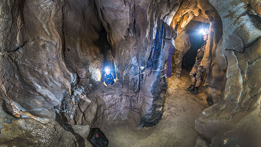
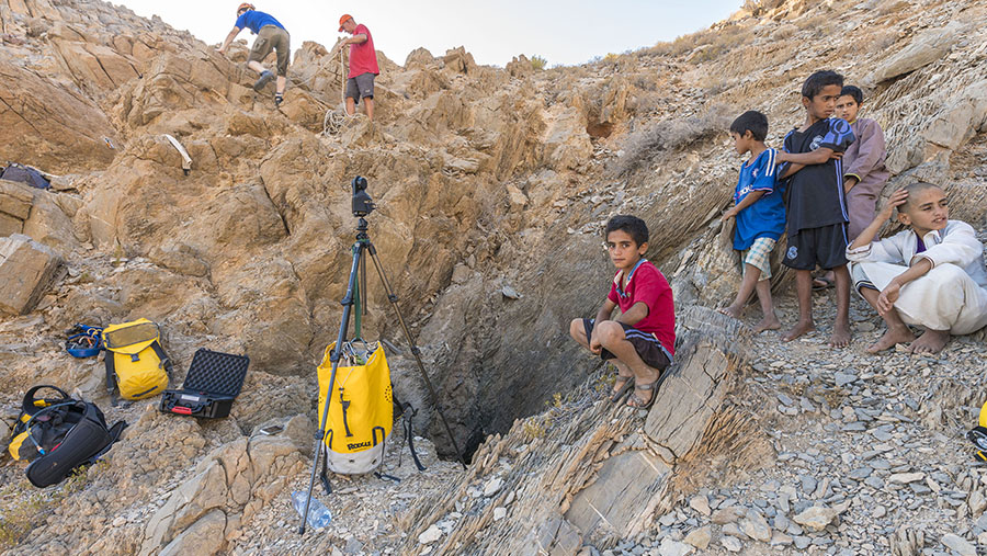
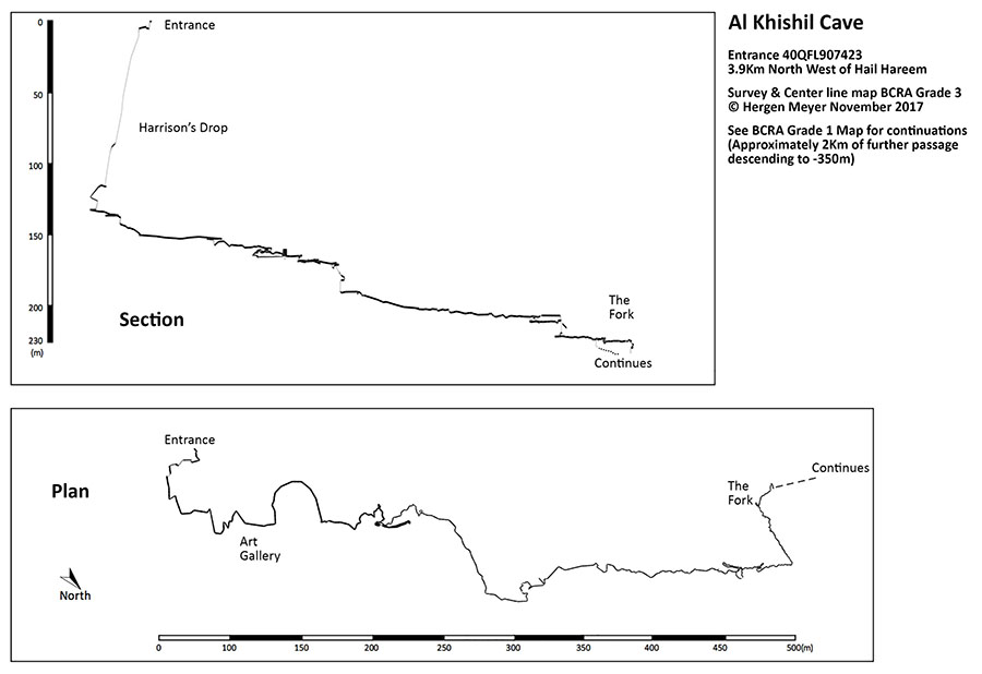
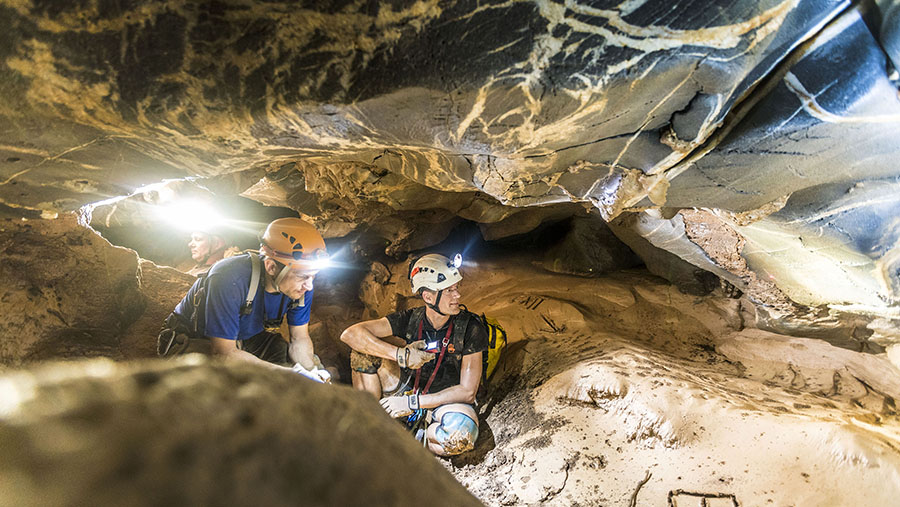
Hergen Meyer a caver from Germany stepped in to help. Hergen crunched the data from Blair’s surveys and came up with a center line plot covering 60 survey points for 300 horizontal meters and a depth of 160m. Paul Emmaus a caver and Nemus photography professional from the Netherlands had been building and developing a 3d scanner that could be used to map caves. Paul’s development had been on hold due to other commitments and another company (Scanse Sweep) bought a similar scanner to market this year. Paul bought one of their units in October and was keen to test it. Simon Cahill, Paul Emmaus, Hergen Meyer and Mikolaj Zielinski a caver from Poland, planned an expedition to photograph the caves and to continue the survey. With a new Disto, the Scanse Sweep 3d scanner and cameras the team was well equipped. The expedition was a huge success and exceeded all expectations. Arriving at Hail Al Hareem on the 30th of October 2017, the team chose to photograph and scan Al Fiqu Cave. The next day’s aim was to take photographs in Al Khishil Cave. A secondary aim was to continue the survey. The team worked hard to take delicate and heavy equipment through the cave. The result after a strenuous and exhausting eighteen hours’ underground was a center line survey from The Entrance to The Fork, a set of incredible photographs and some 3d scans. The 1.3km of passage surveyed, approximately one third of the cave, gives some indication of the complexity of the cave. It will take many expeditions and many more days underground, to produce a fully detailed map.
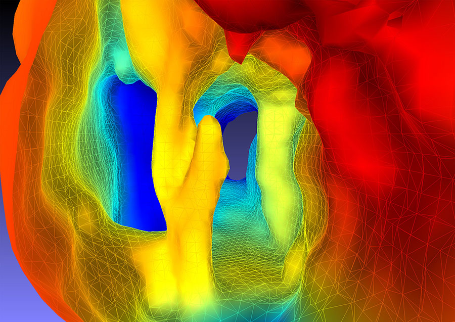
3D Scan of the Fork (made with Scanse Sweep 3D Scanner
Beyond the Fork
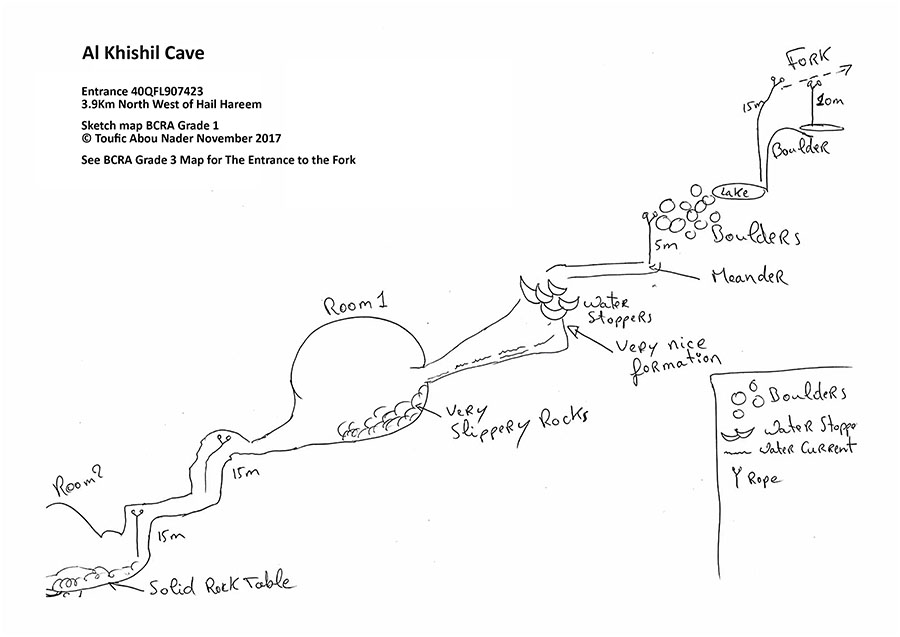
Toufic Abou Nader described the cave and provided a sketch map for the continuations beyond The Fork. Toufic says; “I believe the right fork was the first to be formed, it is very dry and old.” Blair also commented that this section looks very old and her way was obstructed by fragile formations. It is thought the right fork is likely blocked but there are still possibilities to explore. Toufic continues; “to descend through the left fork there is a need to crawl backwards and squeeze through a hole dropping around five meters onto a steeply inclined slab. A further drop, again five meters leads to a crystal clear lake.” However, an easier option discovered on later expeditions is to backtrack twenty meters from the Fork and descend about seven meters through an alternative Drop. This drop avoids the tight squeeze hole and lands you directly on the inclined slab above the Crystal Lake.
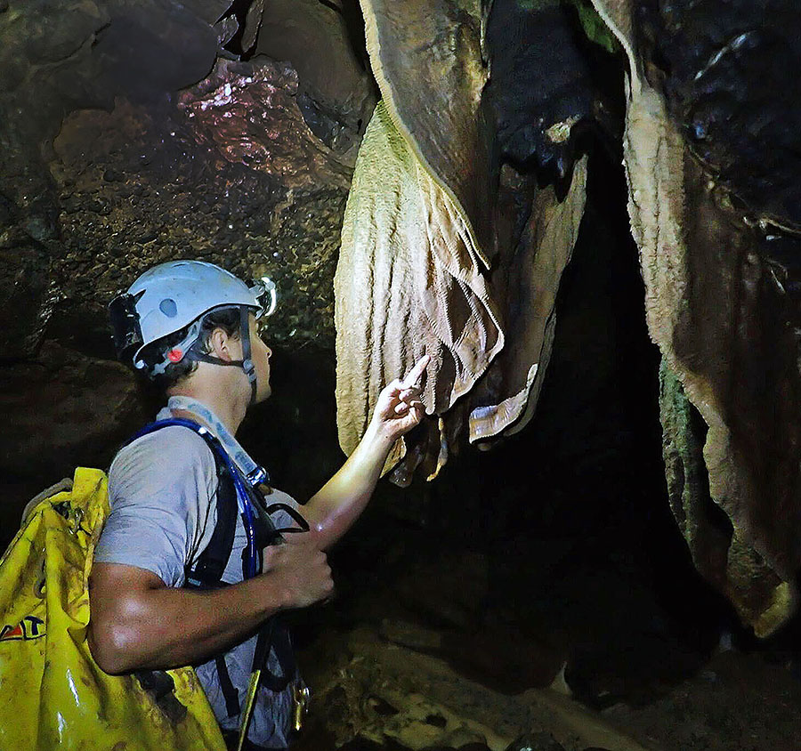
The temperature at this level gets slightly cooler and less humid. The cave also changes drastically. The speleothems are wet and active. Flowstone has formed into draperies (curtain like formations). Rimstone dams have formed cascading gour basins full of clear water. Stalactites and stalagmites up to a meter long extend from the floor and ceiling. Soda straws are active and dripping water. Helictite, a wispy hair-like fragile speleothem appears as if grown in zero gravity. Frostwork a delicate needle-like growth of calcite is present and the trained eye will find cave pearls. Beyond Crystal Lake the passage to the bottom of the cave is inclined and has a further four vertical drops ranging from five to fifteen meters giving a further elevation loss of around 150m.
After the Crystal Lake a boulder section for one hundred meters leads to a ten-meter drop. From this drop, a meander connects to a small room containing the gour basins. A small streamon the left runs towards the end of the cave, sometimes it is visible and sometimes it disappears between the rocks. The room connects to a crawl section before opening to a large room (100m wide and 50m high). The floor of the room is covered with very slippery boulders. The room narrows and the roof drops to form another crawl passage for approximately fifty meters leading to the next vertical drop. This drop leads to another meander that connects to the final vertical pitch. A chamber opens up to a large room similar in size to the pervious room. This room appears not to have any passages leading out. But it leads to a small pond with a solid rock bottom; a feature known as a “Cave Table”. Water must drain here somewhere, but it is not obvious where, maybe through a number of small cracks. An altimeter reading of 1120m was taken, suggesting the cave is about 330m deep and possibly up to 3km long.
Al Fiqu Cave
Al Fiqu Cave was shown to the expatriate cavers by Hassan Ibrahim Almaeeni (United Arab Emirates), himself a keen caver. Hassan had been a member of the exploration team for Al Khishil Cave and during those exploration trips the local villagers told him about other caves and guided him to Al Fiqu Cave. This cave is important for its impressive flow stone decorations. This cave at 47m deep is small compared to other caves in the area but is technically challenging to enter due to a lack of stable rock around the entrance. The speleothems extend from just below the surface to the cave floor (150m2) in huge flowing formations.
Al Naqqah Cave
The group of expatriate cavers who explored Al Khishil Cave & Al Fiqu Cave invited two Omani cavers to visit these caves and take part in a training day with a view to entering Al Khishil Cave. Several months later some Omani cavers returned and spoke to the local villagers. The villagers guided six Omani cavers to the entrance of Al Naqqah Cave, the third cave to be discovered.
Naming the Caves
The naming of important geological features is a controversial topic. In a discussion with Dr. Mohammed Al Kindi and Simon Cahill, Mikolaj Zielinski said that it is important correct names are researched and used. The highest mountain on Earth was named Everest in honour of the British surveyor George Everest. Africa’s largest lake was named Victoria after England’s Queen Victoria. Yet to the local people the highest mountain on Earth already had names; Tibetans call it Chomolungma and the Nepalese call it Sagarmatha. Africa’s largest lake was called Nam Lolwe or NalubaaleI in local languages. With the ease of travel today, communication and information data bases there is no excuse for not doing the necessary research and finding correct names. Simon Cahill said; the first person to allegedly discover or explore an important geological feature should not feel they have the right to name it freely as they wish. It is, for this reason, the names used above should be the ones the caves are known by.
Acknowledgements
Exploring caves takes a huge commitment by many people. A large technical and potentially dangerous cave such as Al Khishil Cave makes the task even more challenging. Exploration and documentation requires fit strong teams with a wide range of skills, knowledge and specialist equipment. More than 20 people have been involved with the exploration to date. Special acknowledgment goes to; Tim Harrison for posting the photograph that leads to the exploration. Simon Cahill for research and leading the initial exploration teams, Blair Hoover for being there all the way through and supporting in every possible way, Christopher Pike for taking the lead on bolting the entrance pitch, Alan Goddard (Australia) & Rayan (Lebanon) for being strong members of the early push and rigging teams, Toufic Nader for pushing beyond what anyone else has been able to do so far and reaching the bottom of the cave, Hergen Meyer for going out of his way to crunch Blair’s data and then join the team to get a centre line survey in one day, Paul Emmaus for taking photographs & scans in an extremely challenging environment, Mikolaj Zielinski for making himself available for almost every trip and hauling bags of kit when the old guys got tired. Hassan Ibrahim Almaeeni (United Arab Emirates) for being a strong push team member and communicating with the local villagers to locate Al Fiqu Cave.
A special thank you goes to the local residents for their kindness and guiding us to two of the caves. The villagers have been welcoming and helpful and shown an interest in the exploration. ■
Words + Photos by: Simon Cahill