Words + Photos By: Sean James
Part 2
This is the second part in the hiking series that will help you get more from your outdoor life in the UAE. Last month, we talked about the clothing and equipment that you would need. A beautiful hike near Masafi was detailed to get you started. The hike was flat, on a good obvious track through wadis, plantations and mountains. The route was a simple out and back route that required no navigation. In addition, you could turn around whenever you liked.
This month we will look at planning and what you should think about before you start. Regular hikers will automatically grab their gear, rush out of the door and know exactly where they are going and how long it will take. However there are important considerations to ensure not only your safety but also to maximise the enjoyment.
If you are hiking with a group or have booked through a commercial operator then they will have planned the logistics and often send you a list of what to bring. We will give you a method of what to run through if you are planning your own outing.
It is always a good idea to have an objective when you want to go out hiking. The old saying “failing to plan is planning to fail” is very true. When considering which routes to hike, both long (all day) or short (1km) there is a useful acronym to remember that will assist you and keep your thoughts logical. It is called the 5Ds. Each D represents part of the planning process. The Ds are: Distance, Duration, Direction, Destination, (D)Journey. These are the basics that you should think about and in future articles we will explain more techniques to help you navigate and operate independently whilst on the hike.
Distance
Whilst at home, technology can help calculate the distance for your hikes in the UAE. There are many websites that allow downloads of existing .gps files. These are trails that people have already hiked and are prepared to share. Here the distance is already calculated when you load on to your device so you know exactly how far you are hiking.
To create my own hike, I find one of the best planning tools is Google Earth. There is a lack of accurate, contoured maps in the UAE so plotting a line of the intended hike on Google Earth gives the exact distance. Of course the accuracy of the distance will depend on how precise you are with your plotting when you are using the software. So now you have the distance. What can you do with it?
Duration
How long do you want to hike for? It can be difficult to calculate how long a hike will take as there are many factors that influence the speed that you walk. We all have friends who when it is their turn to lead, we all know to pack extra food and a head torch. It is certain their intended hike will be longer than anticipated and we will most certainly return to the vehicles in the dark.
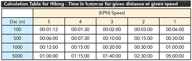
However, once you have the distance you want to hike there is an easy way to calculate how long it will take. Of course there may be a variance for additional food and drink stops and photos but it should be very close. This formula even takes into account the elevation gained and lost. It is best viewed as a table. To make it easier to understand only the 100m, 500m, 1km and 5km distances are shown. I often carry one of these tables with me when I’m out hiking to avoid lengthy calculations whilst balancing on a rocky ridge.
The table shows four different distances down the left and five different speeds of walking across the top.
Example One
You have planned a route that is 1,000m (1km) long and you walk at 2kph. It will take you 00:30:00 (30 minutes).
Example Two
You plan a route of 6,600m (6.6km) and you walk all of it at 4kph with no rests. It will take you 00:01:30 + 00:07.30 + 01:15:00 = 01:24:00 (1 hour and 24 minutes)
Notes on Timing
For the table to work accurately you need to know how fast you are able to walk. This will depend on what type of ground you are hiking over. You should add extra time for ascending and descending. Google Earth will also give you total elevation gain and lose for the hike that you plot.
Time to add for Ascent or Descent
00:10:00per 100 m Ascent
00:05:00per 100 m Descent
Example
You intend to hike a route that is 4kms (4,000m) with 500m of ascent and 500m of descent. The trail is on fairly rough ground and you estimate the slowest person to walk at 3kph.
4,000m = (4 * 00:20:00) = 01:20:00
500m Ascent = (5 * 00:10:00) = 00:50:00
500m Descent = (5 * 00:05:00) = 00:25:00
Total Hiking Time = 01:20:00 + 00:50:00
+ 00:25:00 = 00:02:35
Other factors that may influence the total duration are hiking at night for which you should use a reduced speed of half the normal pace. A heavy pack will also slow your speed by at least 1kph.
Direction
The issue of navigating using bearings and a map holds slightly less importance in the UAE. Satellite signals are very strong and readily available so when you are hiking it is simply a matter of following the line on your GPS device or smartphone. However making sensible decisions or changes whilst on the ground is a key skill. What you thought was possible when looking at Google Earth at home may need a modification when out in the country. A wadi may be steeper or a nearby ridge may simply look more attractive and offer a better view. Keep important points or tick off features in mind along the hike and use your arsenal of navigational skills to become more proficient. Direction may also be a key factor when planning at home. What direction is the wind? Do you want to start walking into it or finish with it helping you? Are you walking into the sun in the morning or finishing with it behind you?
Destination
Destination can be used to help improve your planning for both short and long hikes. For a long hike, consider what is at the end of the hike. Most hikes will be circular so your vehicle will await you. In that case do you want to park somewhere that you can get food and refreshment? What time of the day are you finishing your hike and what will the destination look like then? Will it be different from when you started? Maybe you have parked near a mosque and would feel uncomfortable returning in hiking gear covered in dust at prayer time. Do you want to start by walking uphill or end at your destination with a fast, mood improving stroll downhill?
If you plan a hike that goes point-to-point and is not circular, you will have to arrange transport back such as a taxi or drop cars off beforehand. Destination is all about being aware about what is at the end of your hike. What should you be looking out for?
(D)Journey
Although slightly modified to fit the 5D acronym (D)Journey accounts for the type of experience or terrain you will be hiking over. Does your intended hike fit with your mood? Do you want steep sided valleys, lush flat plains, rolling hills with easy navigation? Or do you want to test yourself a bit and explore somewhere new with only faint trails? Your hike will often be decided by where in the UAE you want to explore. Some people like to visit and explore completely new areas. Others feel more comfortable and prefer to repeat hikes that they have done before. Simply adding a bit more distance or a different approach to a summit can bring something extra to your day out. The UAE is fortunate in that it is relatively compact in area but still has a variety of landscapes. There is something for everyone and each area has unique characteristics. For example, the mountains near RAK are abundant with high plateaus while the knife edge ridges around Masafi offer a different experience and require different skills. Around Munai and Wadi Helo the wadis are gentle and more populated. In contrast the Hatta area offers deep, shady canyons and pools.
The 5Ds is a basic structure to help you start to plan your own hikes. The only way to learn is to plot a route at home and go out and follow it. Next month we will look at how you can navigate with a variety of instruments; compass, map, coordinates, GPS device.
A second step for February
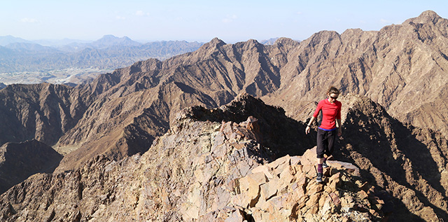
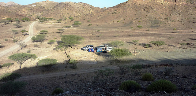
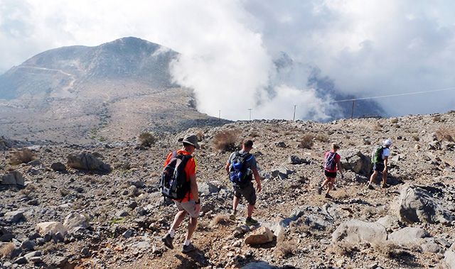
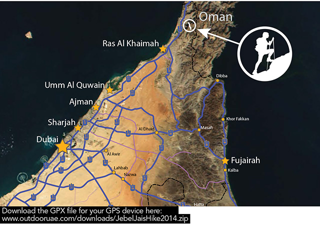
This month’s hike will put you right in the middle of the mountains near Ras al Khaimah. It offers dramatic vistas and takes advantage of the new road up to Jebel Jais. You will be rewarded with a fantastic day out for the whole family and spectacular views of the mountains. Again the navigation is easy and you are never far from the car. The route wanders in a clockwise circular route around a high plateau. There are several fields and shady resting places so the hike can be split up into sections. This is a great place to practice using the compass to navigate. It is possible to catch glimpses of the sea in one direction and the mountains of Musandam and Oman in the other. This hike can be as short or as long as you like. I have used the area frequently to train clients in navigation. If you want to make it a weekend there are also some excellent camping sites nearby. After your hike drive further up the road, park at the flag and look out over the city of Ras al Khaimah and the Arabian Gulf.
Directions to the start
Enter the start point into your GPS device or follow the directions from Google below.
Follow the E311 north to RAK. When it finishes continue on the E11/Khuzam Road for 8.1km. Turn right onto E11. Continue 8.1km. Turn right onto E11/Khuzam Rd. Continue for 2.7km. Turn right onto Khuzam Rd and go through one roundabout. Continue for 2.8km. At the next roundabout, take the second exit. Go through two more roundabouts for 5.3km. Turn right. Drive 1.5km. Turn right and drive 5.1km.Turn right toward Jabel Al Jais Road (New) and drive 8km. At the roundabout turn left toward Jabel Al Jais Road (New) and drive 16.4km to a parking area on a wide bend. You will be able to see cultivated fields close by. Park safely off the road where you will not cause any problems. The route is to the left (west) of the road.